Coastline, Beaches & Rivers of Philippines
Discovery-Guelos - Green Earth Awareness 2025


Nagsasa Cove - The Hidden Paradise of Zambales,Philippines
23 April 2024
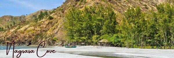
The Nagsasa Cove in San Antonio, Zambales, used to be rocky until the eruption of Mt. Pinatubo in 1990’s, which chucked tons of volcanic ash in many parts of the region. Nagsasa Cove has similar features as Anawangin: a beach of ash that absorbs heat faster than the usual sand; a blanket of agoho trees, a type of casuarina tree, often mistaken for pine trees; the azure sea teeming with life and colour; and gently sloping hills framing the view.

The village was first called Pamalisaraoan and later as PAMISARAOAN. PAMISARAOAN was given the status of a barrio, as part of Pueblo Uguit (now Castillejos) in 1836. However, in the year 1846, when the barrio of Alasis or Aluciis, which then belonged to Cabangan, was made into a new pueblo, Barrio PAMISARAOAN was detached from Uguit and was subsequently attached to San Narciso. The town leader, Teniente Primero, in that period was Don Gregorio Bañaga, who governed from 1836 to 1849. He was succeeded by Don Vicente Lacuesta in 1849 (governing as Teniente Absoluto), when San Antonio was finally recognized and given the status of a pueblo on May 12, 1849 as a result of two petitions for separation from the town of San Narciso. The first was in 1848 and the second was on March 8, 1849. The latter petition was signed by 31 top leaders of the community headed by Tiniente Primero Don Vicente Lacuesta.
The last mayor Teniente Absoluto was Don Santiago Ladrillono. He was succeeded by Don Dimas Pascasio as the first gobernadorcillo in 1856. The prominent citizens selected their leaders every year thereafter. In 1891 to 1898, Don Pablo Corpus was the only Capitan Municipal selected after which Don Felix Magsaysay was appointed as the first Presidente Municipal and many more followed up to 1931 to 1945. San Antonio was the site of the US Naval Communications Station San Miguel, now the Naval Education and Training Command. Now a Second Class Municipality, and under the leadership of Hon. Edzel L. Lonzanida, MD, San Antonio is experiencing a significant rise in tourist arrivals. With the improvements in tourism-related infrastructure like road rehabilitation, construction of first-class health facilities and major renovation of the San Antonio Public market, and over-all beautification and promotion of the town, San Antonio is truly on its way to become the crown jewel of tourism in Zambales and Region III.

How to Get to Nagsasa Cove
How to get there by public transport. Take the bus (check bus station to Zambales) to Iba or Sta. Cruz, Zambales and get off at the San Antonio Public Market near the Municipal Hall. Alternatively, you can also travel by bus to Olongapo and another bus to San Antonio, and get off at the same market. Look for a tricycle transport to take you to Pundaquit and then rent a boat to Nagsasa Cove or also by trekking is another good option.
Suggested Travel Agency offering Nagsasa Cove Tour
McTrail Travel and Tours, linked below.

Historical Facts Surrounding Nagsasa Cove
Nagsasa Cove was once a rainforest inhabited by Aetas and rocky beaches. In the 1980s, the mountain slopes around Nagsasa Cove were covered with tropical rainforest and inhabited by Aetas since many years past. The coastline was mostly rocky, with shorter spots of beach all around. A few distance distance beyond the coastline was of abundant coral reef, lushing with all kinds of marine life.
The area was once a practice area for US warplanes, decade ago. This densely forest mountains were utilized as an area for bombing exercise areas. The locals at that time were given enough warning not to leave their homes when the military exercise started, but few instances the those been working in the forest area where lesser time to get out, sometimes hit with bombing debris. Some famous military bases like Crow Valley range, the area was not exactly an official part of any US military reservation. Across the mountains there were other military bases like Clark Air Force Base to the northeast, and Subic Naval Station – base of the US Seventh Fleet base – to the southeast, apart from the US Navy communications station in San Miguel further up north, but still within San Antonio town, where the cove is used for military exercises.

The eruption of Pinatubo changes the face of Nagsasa Cove, 12 June 1991, Mount Pinatubo erupted and blew massive ashfalls covering the numerous towns of Zambales-Tarlac-Pampanga-Bataan boundaries, including Nagsasa and the neighbouring coves of Anawangin, Talisayin, and Silanguin. The Aetas, who lived in smaller communities all around Zambales-Bataan mountains, severely affected and were force to relocate dislocation due to the threatening lahar flow and there were casualties along the path and they were devastated as they consider the mountains a sacred place.
Lahar covered the coastline and created new face of beaches. Many months after the eruption in 1991, with frequent rain, eventually settling ashes and lahars were slowly eroded. A form of ecosystem rose form the movement of dust and ashes washed away down to rivers and the sea, making new sight of beaches. It became a fresher and new land contours surrounding the new coastline.
New way of life where in the past twenty years since the Pinatubo eruption, the new beach at the point of the Nagsasa cove slowly came to life, new grown sea grass, a scattering of small shells, family of corals growing and populating the seabed, and bounty signs of growing marine life. Nagsasa highlands around the cove took some time the vegetation to populate.
Agojo trees that look like a pine tree calledcasuarina trees, The agojo trees surrounding the areas were from the Casuarina family. Agojo is strikingly similar to pine with their needle-like leaves and it is a flowering tree and a hardwood, while pine is a conifer and softwood. Agojo and many other Casuarina species thrive around the seashore. They reproduce fast and now considered invasive species in some areas.
Wild Horse Creek “A river runs through it,” as many said, is more of a creek ending in shallow tidewater pools than a river, although further upstream are rapids and falls. Previously called Wild Horse Creek follow the headwaters, and over the stretch you’re able to discover that an alternative route by land between Nagsasa and the other side of the hilltops across the mountains via Cinco Picos, with the Subic famous Bay at the other end.


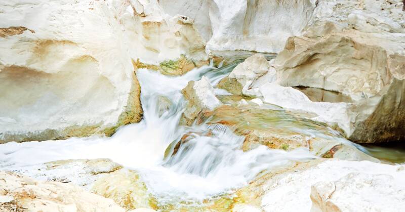
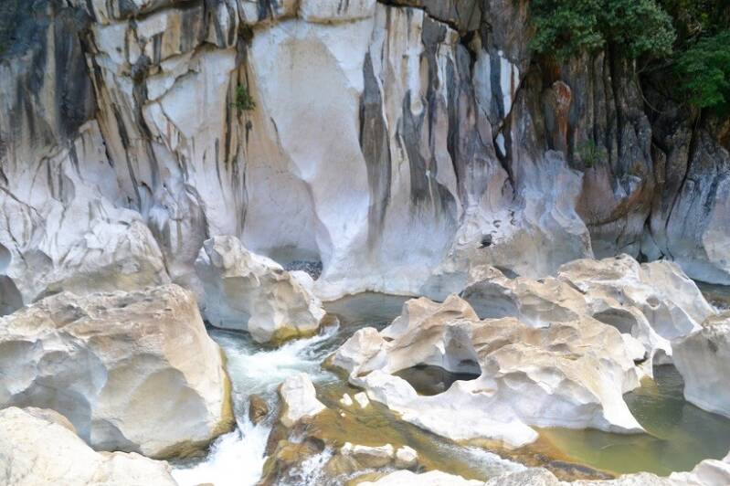
Tinipak River - The Hidden Gem of Mount Daraitan, Tanay, Rizal, Philippines
Rizal Province, Philippines 22 November 2023


Mount Daraitan is a mountain range located along the borders of Tanay, Rizal and General Nakar, Quezon Province, Philippines. Daraitan came from two words - dara, a local term for limestone and aeta, a Filipino term usually used to describe native people of dark skin. Mount Daraitan is a part of the vast ancestral land of the Dumagat tribe and is protected by military as history of insurgencies and armed presence has been reported to this place. However, in general, Daraitan is considered to be safe for mountain trekkers and visitors. At the foot of Sierra Madre Mountain in village Daraitan, Tanay, Rizal runs the Tinipak River featuring a sporadic formation of limestones and crystal clear river. Tinipak or Agos River, is a river that flows from Tanay, Rizal to General Nakar, Quezon Province and found throughout the Sierra Madre mountain ranges. The dramatic marble rock formations, an in-cave natural swimming pool and its proximity to Metro Manila, make this gem a perfect getaway for visitors locally and internationally. The river is popular to mountaineers since this is the main attraction after summiting Mount Daraitan and awarded as the cleanest inland body of water in the region.


The word “Tinipak” which gives the name to the river, literally means “to cleave” or “to split”, which appropriately captures the imposing limestone structures that border the rivers’ bank. Tinipak River’s amazing beauty makes for ideal photographic backdrop, making a popular destination for visitors seeking to record unforgettable moments. Tinipak River is the perfect getaway from the bustle and hustle of the city because of its serene surroundings. The limestone features almost the entire stretch of Tinipak River banks is a


sedimentary rock composed principally of calcium carbonate (calcite) or the double carbonate of calcium and magnesium (dolomite). It is usually composed of tiny fossils, shell fragments and other fossilized debris. These fossils are frequently visible to the unaided eye on close examination of the stone surface, however this is not the case for Tinipak River which purely sedimentary rock. Some varieties of limestone have an extremely fine grain and overtime the limestone deposits of Tinipak River most likely underwent a metamorphism during major geological events resulting in a recrystallizing as marble.
As the Philippines is one of the most vulnerable countries in the world to climate change and with the increased intensity of typhoons and rainfall, many conservationist joined forces to conserve and protect the Kaliwa Watershed Forest Reserve, the home to the indigenous Dumagat-Remontado communities, who have been stewards of their ancestral domain within the Sierra Madre since time immemorial. The Tinipak River spring is a sacred site in Barangay (Village) Daraitan, within the Dumagat-Remontado ancestral domain and declared an indigenous community conserved area. Daraitan and Tinipak River provides important economic activities to local communities, from tourism, to non-timber forest products for livelihood. It is an ecologically important water system that enhances climate resilience. It provides key ecosystem services to downstream areas, playing an integral role in regulating water flow to the National Capital Region or Greater Manila where forests act as natural water filters.


Information Links when travelling to Philippines


Apo Reef Natural Park, Philippines
Sablayan, Occidental Mindoro, Philippines
If you're interested in travelling to Apo Reef, tap the linked image.

If you're interested travelling to Apo Reef, tap the linked image above
Philippine’s Apo Reef is the world’s second-largest reef streaming with marine rich life and one of the country’s scuba diving paradise. This coral isle complex is considered the largest of its kind in Asia. The reef is divided by a narrow lagoon surrounded by a century-old mangrove forest and inhabited by some 285 species of marine species, including sharks, stingrays, and mantas and school of jack and snappers, tropical and crevice-dwelling moray, blemish and gobi and 500 coral species. The Park has three bird-populated islands comprises of the Apo Island, Apo Menor (Binangaan) and Cayos del Bajo Tinangkapang. The main geographical features of Apo Reef is submerged and the largest is Apo Island (22.0) hectares which harbours mangroves and shoreline vegetations, whereas, the Apo Menor(Binangaan) is rocky Iimestone island with relatively few vegetation and Cayos del Bajo(Tinangkapang) around 200-300 sq.m. is a coralline rock formation with no vegetation.


The thousands of islands in the Philippines
Play the video selections and be amazed
Destination: Palawan, Philippines
Video Courtesy of Palawan Tourism
Travel video courtesy of Touropia
Destination: Negros Oriental, Philippines
Video Courtesy of Dumaguete Tourism
Manila, Philippines (Video courtesy of Exploropia)
Destination: Ilocos Norte, Philippines
Video Courtesy of VPI Travel Ilocos
